Monday, March 13, 2017

Gathering Data for Trempealeau County

GOAL AND OBJECTIVES

The goal of this lab was to gather data from online sources and import the data into a single geodatabase. This was done largely through a Python script designed to project and clip the data while importing it into the geodatabase. The study area for this lab was Trempealeau County and is a continuation of the previous lab's focus on frac sand mining in the county.

The data came from a variety of online sources. This included DOT railroad data, USGS land cover and DEM data, USDA cropland data, Trempealeau County land records, and USDA NRCS soil data. The Trempealeau County land records contained a geodatabase for the county, which was used as the main geodatabse for the lab.


METHODS

The basic workflow is as follows:

First a workspace had to be created. Since a large amount of data would be downloaded, a temporary working folder was created to store the files until they were processed and put into a geodatabase.

Next, the data was downloaded. First, the USGS data was obtained. This was done by navigating to the USGS National Map Viewer, selecting Trempealeau County, and downloading the National Land Cover and DEM data. Next, the USDA website was used to download the land cover data. Next, the Trempeleau County Land Records geodatabase was downloaded from the website. This would serve as the main geodatabase for the project. Lastly, the USDA NRCS Web Soil Survey data was downloaded from the USDA website.

The data, all kept in the working folder, was then unzipped to allow it to be used. The geodatabase was moved to the project folder to serve as the main geodatabase. The USDA Soil Survey data was then imported to the geodatabase after joining the tabular data into the shapefile using a Microsoft Access macro. Next, the railroad data was processed. Since this shapefile expanded beyond the scope of Trempealeau County, it was clipped to the county and imported to the geodatabase. Importing it into the feature dataset automatically projected it into the correct Trempealeau County projection.

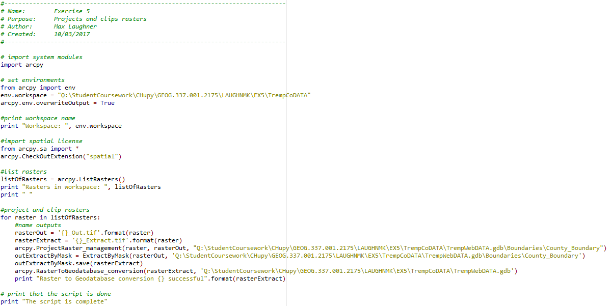
Next, a Python script was written to project, clip, and import the raster data into the geodatabase. This included the NLCD, the USGS DEM, and the NASS data. The Python script is shown in the blog post about scripting, under Script 1. This script was designed to loop through every raster in a given folder and project it, clip it to Trempealeau County, and import it into the geodatabase.

Lastly, the rasters were used to create a map of Trempealeau County in ArcMap. This is shown in the results section.


RESULTS

Shown below in Figure 1 is the map created from the raster files. The legend for the NASS and NLCD maps have a large number of categories, so they are shown separately below in Figure 2.

Figure 1: Map created from raster data for the county

Figure 2: Legends for the map above

Shown below in figure 3 is a table showing the data quality for each dataset used. This information was obtained from the metadata for each set. Notice there are many values enetered as "NA." This means the information could not be found in the metadata or this did not apply for this dataset.

Figure 3: Data quality for each dataset used

CONCLUSION

This lab gave an introduction to basic data gathering from a variety of sources, as well as some Python scripting. The emphasis in this lab was data quality assessment. It is obviously important to know how to download data, but more important than that is being able to assess the quality of the data, otherwise results will be invalid.


Friday, March 10, 2017

Python Scripts

BACKGROUND

Python is an Integrated Development Environment, or IDE, that allows users to write code, debug, and run it. Scripting is useful when doing repetitive work. Writing a script instead of doing repetitive scripts multiple times can minimize the amount of time it takes to carry out tasks and can minimize room for error.


GOAL

The goal is to learn basic Python scripting and be able to implement it in future work. These scripts should obviously be functional, but also important is that they are well commented so other users can easily understand them.


SCRIPTS

Script 1:


This script projects and clips all rasters within the workspace geodatabase.


Script 2:
This script runs several SQL queries on a vector and saves the results.


Script 3:


This script assigned rasters to variables, weights a variable, and adds them. The result is then saved.


Thursday, March 2, 2017

Background on Sand Mining in Western Wisconsin

OVERVIEW

What is frac sand mining?

Frac sand is used for injecting into oil and gas wells under high pressure to enlarge fractures and create new ones. The fluid is then pumped out. Frac sand mining is the process of extracting this sand from the ground. The sand needed for this process must be of round, uniform size, quartz sand which is found in abundance in Western Wisconsin.


Where is frac sand found in Wisconsin?

The sand is taken from sandstone formations, which spread across Western Wisconsin. Below (Figure 1) is a map taken from the 2012 Wisconsin Geological and Natural History Survey. This shows the spread of sandstone across Wisconsin. Notice how it is spread densely across the Central and Western side of the state. This distribution is caused by glacial deposits and results in round sand of a size perfect for industrial applications. There are other deposits in the Southern and Eastern side of the state, but these grains tend to be smaller and more angular, which is less useful for industrial applications.

Figure 1: Locations of sandstone formations across Wisconsin

What are some of the issues associated with sand frac mining in Western Wisconsin?

The magnitude of the environmental impact varies greatly depending on the type of operation and the location. Common impacts are described below.

Frac sand mining produces a significant amount of air pollution. This is from two sources. The first is dust that is released during the blasting process and the subsequent handling of the sand. The second is from the machinery used to extract and process the sand, such as extraction equipment, generators, pumps, heavy transportation vehicles, and more.

Water pollution is also a result of the process. This is more site-specific than air pollution. Water pollution is created from several sources, including cleaning, transportation, dust control, and sorting. These can contaminate water with industrial chemicals and affect the availability of water for nearby wells.

Another impact of the mining is the effect it has on the land surface. Reaching and extracting the sand requires vegetation to be removed, which affects wildlife habitats. A reclamation process is possible on some mines after they are closed, but this process is difficult and expensive. Noise is also a problem during the process, which similarly affects local wildlife.

Traffic from transportation equipment is also a concern. These heavy transportation vehicles causes significant wear on roads and can be a burden by blocking local traffic.


How GIS will be used to further explore these issues

GIS can be used to study how certain areas will be impacted by sand mines. Environmental data including wildlife, water, air quality, and climate data can be used to predict possible impacts. For example, fish habitats could be compared with likely water pollution scenarios to determine how the habitat will be affected. Climate data could also be assessed to determine where and how far the air pollution from mines would travel.

Non-environmental impacts can also be studied. The wear of roads could be predicted along with traffict impacts. Noise pollution could also be predicted for those living nearby a mine.

GIS systems are critical to predicting impact of virtually every aspect of sand mines. This data can be used to find optimal locations for these mines to minimize negative impacts.


SOURCES

Brown, Bruce. "Frac Sand in Wisconsin." Wisconsin Geological and Natural History Survey (2012): n. pag. Wcwrpc.org. Web.

Pearson, Thomas W. "Frac Sand Mining in Wisconsin: Understanding Emerging Conflicts and Community Organizing." Culture, Agriculture, Food and Environment 35.1 (2013): 30-40. Wisconsin DNR. Jan. 2012. Web.

Kremer, Rich. "Is Frac Sand Mining Causing Metal Contamination In Groundwater?" Wisconsin Public Radio. N.p., 14 Oct. 2016. Web. 02 Mar. 2017.